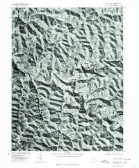
1976 Map of Pine Grove
USGS Topo · Published 1979About this map
Pine Grove and the surrounding valley of Fishing Creek are revealed in high detail in this 1970s orthophotoquad, which uses rectified aerial imagery to show the physical layout of these Wetzel County communities. The settlement of Reader occupies a bend in the creek to the west, while Jacksonburg is situated to the southeast along the South Fork. This specific type of survey, produced in cooperation with the Soil Conservation Service, provides an unfiltered view of the land use and timber patterns across the steep, dissected ridges that define the local geography. Unlike traditional line maps, this imagery captures the exact footprints of structures and the winding path of the North Fork, documenting the footprint of these Appalachian settlements before later decades of development.
Find a feature on this map
6 named features on this map. Tap any name to fly to it.
Don’t see what you’re looking for? This feature index may not catch every label — zoom into the map to look around manually.
Map Details
Editions of this 1976 Pine Grove Map
This is the sole edition of this map. No revisions or reprints were ever made.
Other maps of this area

1903 · Littleton
USGS Topo · 1:62,500

1905 · Centerpoint
USGS Topo · 1:62,500

1905 · West Union
USGS Topo · 1:62,500

1905 · Littleton
USGS Topo · 1:62,500

1906 · New Martinsville
USGS Topo · 1:62,500

1924 · New Martinsville
USGS Topo · 1:62,500

1924 · Centerpoint
USGS Topo · 1:62,500

1924 · Littleton
USGS Topo · 1:62,500

1924 · West Union
USGS Topo · 1:62,500

1925 · Centerpoint
USGS Topo · 1:62,500