
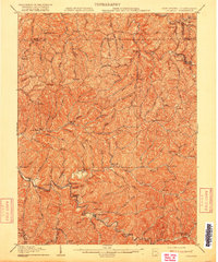
1905 Map of Littleton
USGS Topo · Published 1905About this map
Littleton serves as a prominent rail hub in this 1905 survey, where the B and O RR follows the winding path of Wheeling Creek. The terrain is characterized by a dense network of narrow hollows and steep ridges, such as Miller Ridge and Lowman Ridge, which dictated the early settlement patterns of the region. Small communities like Saint Joseph, Millsboro, and Silver Hill are tucked into these drainages, connected by a web of local roads that mirror the intricate hydrology of Fishing Creek and the West Virginia Fork.
Find a feature on this map
116 named features on this map. Tap any name to fly to it.
Don’t see what you’re looking for? This feature index may not catch every label — zoom into the map to look around manually.
Map Details
Editions of this 1905 Littleton Map
2 editions found
Other maps of this area

1902 · Clarksburg
USGS Topo · 1:62,500

1903 · Littleton
USGS Topo · 1:62,500

1904 · Cameron
USGS Topo · 1:62,500

1905 · Mannington
USGS Topo · 1:62,500

1905 · Rogersville
USGS Topo · 1:62,500

1905 · Centerpoint
USGS Topo · 1:62,500

1905 · West Union
USGS Topo · 1:62,500

1905 · Clarington
USGS Topo · 1:62,500

1906 · New Martinsville
USGS Topo · 1:62,500

1910 · Clarksburg
USGS Topo · 1:62,500