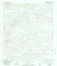
1983 Map of Pine Mountain West
USGS Topo · Published 1984About this map
San Francisco Ranch sits at the heart of this high-desert landscape in Brewster County, marking a site of isolated ranching activity in the Texas Big Bend region. The terrain is defined by the massive eastern bulk of Pine Mountain and the dendritic drainage patterns of San Francisco Creek, which winds through the center of the sheet joined by tributaries like Rough Creek and Kincaid Creek. Evidence of mid-century infrastructure is sparse but functional, centered around a private Landing Strip and a series of primitive transport routes labeled as Jeep Trails. The presence of several tanks and the named landmark Cunningham further illustrates the pastoral management of this arid environment, where water access and rugged navigation were the primary concerns for those working the land in the early 1980s.
Find a feature on this map
10 named features on this map. Tap any name to fly to it.
Don’t see what you’re looking for? This feature index may not catch every label — zoom into the map to look around manually.
Map Details
Editions of this 1983 Pine Mountain West Map
This is the sole edition of this map. No revisions or reprints were ever made.
Other maps of this area

1917 · Hood Spring
USGS Topo · 1:62,500

1918 · Bone Spring
USGS Topo · 1:125,000

1918 · Hood Spring
USGS Topo · 1:62,500

1918 · Dove Mountain
USGS Topo · 1:62,500

1920 · Longfellow
USGS Topo · 1:125,000

1920 · Marathon
USGS Topo · 1:62,500

1921 · Marathon
USGS Topo · 1:62,500

1931 · Hood Spring
USGS Topo · 1:62,500

1954 · Fort Stockton
USGS Topo · 1:250,000

1958 · Fort Stockton
USGS Topo · 1:250,000