
1980 Map of Piney Peak
USGS Topo · Published 1988About this map
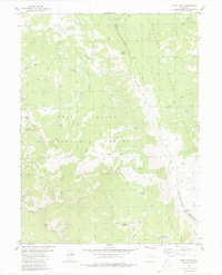
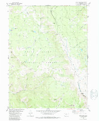
Piney Peak and the high ridges of the White River National Forest dominate this 1980s topography, showing a landscape defined by sharp elevation changes and high-altitude hydrology. The map captures the convergence of the Arapaho National Forest and the Eagles Nest Wilderness, where the county line between Eagle and Summit counties follows the natural spine of Elliott Ridge. This era of surveying illustrates the extensive network of pack trails used for access before modern development, connecting remote water sources like Beaver Dam Lake and Mather Spring. The drainage patterns of the Piney River and Deep Creek are meticulously charted, revealing the complex basin systems that feed the region's lakes, including Slough Grass Lake and Mahan Lake. Geologic landmarks such as Chimney Rock and Meridian Peak provide clear reference points for those studying the physical geography of the Gore Range area.
Find a feature on this map
44 named features on this map. Tap any name to fly to it.
Don’t see what you’re looking for? This feature index may not catch every label — zoom into the map to look around manually.
Map Details
Editions of this 1980 Piney Peak Map
3 editions found
Historical Maps of Eagle County Through Time
116 maps found

1949 Holy Cross
Eagle County, CO

1951 Holy Cross
Eagle County, CO

1961 Cottonwood Pass
Eagle County, CO

1961 Leon
Eagle County, CO

1961 Red Creek
Eagle County, CO

1961 Toner Reservoir
Eagle County, CO

1962 Grouse Mountain
Eagle County, CO

1962 Suicide Mountain
Eagle County, CO

1962 The Seven Hermits
Eagle County, CO

1970 Crooked Creek Pass
Eagle County, CO

1970 Mount Jackson
Eagle County, CO

1970 Mount Of The Holy Cross
Eagle County, CO

1970 Pando
Eagle County, CO

1970 Vail East
Eagle County, CO

1970 Vail West
Eagle County, CO

1972 Burns South
Eagle County, CO

1972 Castle Peak
Eagle County, CO

1972 State Bridge
Eagle County, CO

1977 Sugarloaf Mountain
Eagle County, CO

1980 Lava Creek
Eagle County, CO
1980 Piney Peak
Eagle County, CO

2010 Castle Peak
Eagle County, CO

2011 Burns South
Eagle County, CO

2011 Cottonwood Pass
Eagle County, CO

2011 Crooked Creek Pass
Eagle County, CO

2011 Grouse Mountain
Eagle County, CO

2011 Lava Creek
Eagle County, CO

2011 Leon
Eagle County, CO

2011 Mount Jackson
Eagle County, CO

2011 Mount of the Holy Cross
Eagle County, CO

2011 Pando
Eagle County, CO

2011 Piney Peak
Eagle County, CO

2011 Red Creek
Eagle County, CO

2011 State Bridge
Eagle County, CO

2011 Sugarloaf Mountain
Eagle County, CO

2011 Suicide Mountain
Eagle County, CO

2011 The Seven Hermits
Eagle County, CO

2011 Toner Reservoir
Eagle County, CO

2011 Vail East
Eagle County, CO

2011 Vail West
Eagle County, CO

2013 Burns South
Eagle County, CO

2013 Castle Peak
Eagle County, CO

2013 Cottonwood Pass
Eagle County, CO

2013 Crooked Creek Pass
Eagle County, CO

2013 Grouse Mountain
Eagle County, CO

2013 Lava Creek
Eagle County, CO

2013 Leon
Eagle County, CO

2013 Mount Jackson
Eagle County, CO

2013 Mount of the Holy Cross
Eagle County, CO

2013 Pando
Eagle County, CO

2013 Piney Peak
Eagle County, CO

2013 Red Creek
Eagle County, CO

2013 State Bridge
Eagle County, CO

2013 Sugarloaf Mountain
Eagle County, CO

2013 Suicide Mountain
Eagle County, CO

2013 The Seven Hermits
Eagle County, CO

2013 Toner Reservoir
Eagle County, CO

2013 Vail East
Eagle County, CO

2013 Vail West
Eagle County, CO

2016 Burns South
Eagle County, CO

2016 Castle Peak
Eagle County, CO

2016 Cottonwood Pass
Eagle County, CO

2016 Crooked Creek Pass
Eagle County, CO

2016 Grouse Mountain
Eagle County, CO

2016 Lava Creek
Eagle County, CO

2016 Leon
Eagle County, CO

2016 Mount Jackson
Eagle County, CO

2016 Mount of the Holy Cross
Eagle County, CO

2016 Pando
Eagle County, CO

2016 Piney Peak
Eagle County, CO

2016 Red Creek
Eagle County, CO

2016 State Bridge
Eagle County, CO

2016 Sugarloaf Mountain
Eagle County, CO

2016 Suicide Mountain
Eagle County, CO

2016 The Seven Hermits
Eagle County, CO

2016 Toner Reservoir
Eagle County, CO

2016 Vail East
Eagle County, CO

2016 Vail West
Eagle County, CO

2019 Burns South
Eagle County, CO

2019 Castle Peak
Eagle County, CO

2019 Cottonwood Pass
Eagle County, CO

2019 Crooked Creek Pass
Eagle County, CO

2019 Grouse Mountain
Eagle County, CO

2019 Lava Creek
Eagle County, CO

2019 Leon
Eagle County, CO

2019 Mount Jackson
Eagle County, CO

2019 Mount of the Holy Cross
Eagle County, CO

2019 Pando
Eagle County, CO

2019 Piney Peak
Eagle County, CO

2019 Red Creek
Eagle County, CO

2019 State Bridge
Eagle County, CO

2019 Sugarloaf Mountain
Eagle County, CO

2019 Suicide Mountain
Eagle County, CO

2019 The Seven Hermits
Eagle County, CO

2019 Toner Reservoir
Eagle County, CO

2019 Vail East
Eagle County, CO

2019 Vail West
Eagle County, CO

2022 Burns South
Eagle County, CO

2022 Castle Peak
Eagle County, CO

2022 Cottonwood Pass
Eagle County, CO

2022 Crooked Creek Pass
Eagle County, CO

2022 Grouse Mountain
Eagle County, CO

2022 Lava Creek
Eagle County, CO

2022 Leon
Eagle County, CO

2022 Mount Jackson
Eagle County, CO

2022 Mount of the Holy Cross
Eagle County, CO

2022 Pando
Eagle County, CO

2022 Piney Peak
Eagle County, CO

2022 Red Creek
Eagle County, CO

2022 State Bridge
Eagle County, CO

2022 Sugarloaf Mountain
Eagle County, CO

2022 Suicide Mountain
Eagle County, CO

2022 The Seven Hermits
Eagle County, CO

2022 Toner Reservoir
Eagle County, CO

2022 Vail East
Eagle County, CO

2022 Vail West
Eagle County, CO