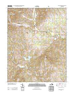
2013 Map of Piney River
USGS Topo · Published 2013About this map
Lowesville and the surrounding Nelson County countryside are defined by a complex network of waterways and ridge lines where the Blue Ridge foothills meet the Virginia Piedmont. The Piney River and Little Piney River drain the northern reaches of this area, while the Buffalo River cuts across the south. This 2013 survey illustrates a landscape of small settlements like Gidsville and Clifford, connected by a dense web of secondary routes such as Lowesville Rd and Saint Marys Rd. Land use is distinctly agricultural and rural, highlighted by the presence of the Fulcher Family Farms Airport near Indian Creek. Named peaks including Thompson Mountain, Mobley Mountain, and Scott Mountain anchor the terrain, while numerous smaller drainages like Maple Run and Naked Creek illustrate the intricate local topography that has shaped the region's historic property lines and community development.
Find a feature on this map
106 named features on this map. Tap any name to fly to it.
Don’t see what you’re looking for? This feature index may not catch every label — zoom into the map to look around manually.
Map Details
Editions of this 2013 Piney River Map
This is the sole edition of this map. No revisions or reprints were ever made.
Other maps of this area

1892 · Buckingham
USGS Topo · 1:125,000

1894 · Lexington
USGS Topo · 1:125,000

1935 · Amherst
USGS Topo · 1:48,000

1936 · Vesuvius
USGS Topo · 1:48,000

1939 · Amherst
USGS Topo · 1:62,500

1941 · Vesuvius
USGS Topo · 1:62,500

1943 · Lovingston
USGS Topo · 1:62,500

1946 · Lovingston
USGS Topo · 1:62,500

1947 · Roanoke
USGS Topo · 1:250,000

1950 · Amherst
USGS Topo · 1:62,500