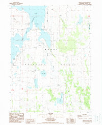
1988 Map of Pinnacle Lake
USGS Topo · Published 1988About this map
Clear Lake Reservoir dominates the northern reaches of this High Desert landscape, serving as a focal point for the Clear Lake National Wildlife Refuge in northeastern California. This late 1980s survey illustrates a region where water management and conservation boundaries intersect. South of the reservoir, the Modoc National Forest encompasses a terrain defined by seasonal water bodies and drainage systems. The map traces the paths of Mowitz Creek and Boles Creek as they navigate the volcanic plateau. Smaller features like Red Lake and Pinnacle Lake provide critical reference points within the forest's expansive grid. The presence of established township lines such as t47n t46n and r7e r8e highlights the systematic land division used for resource management in this corner of the state.
Find a feature on this map
10 named features on this map. Tap any name to fly to it.
Don’t see what you’re looking for? This feature index may not catch every label — zoom into the map to look around manually.
Map Details
Editions of this 1988 Pinnacle Lake Map
This is the sole edition of this map. No revisions or reprints were ever made.
Other maps of this area

1886 · Alturas
USGS Topo · 1:250,000

1886 · Modoc Lava Bed
USGS Topo · 1:250,000

1892 · Modoc Lava-Bed
USGS Topo · 1:250,000

1892 · Alturas
USGS Topo · 1:250,000

1951 · Clear Lake Reservoir
USGS Topo · 1:62,500

1952 · Hackamore
USGS Topo · 1:62,500

1954 · Alturas
USGS Topo · 1:250,000

1958 · Alturas
USGS Topo · 1:250,000

1962 · Alturas
USGS Topo · 1:250,000

1962 · Steele Swamp
USGS Topo · 1:62,500