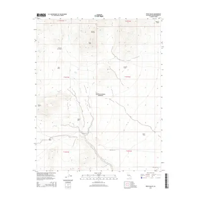
2015 Map of Pinto Valley
USGS Topo · Published 2015About this map
The New York Mountains dominate the northern landscape of this Mojave Desert survey, where high-elevation drainage systems like Fourth of July Canyon and Caruthers Canyon descend into the broad basins of Pinto Valley and Lanfair Valley. This area is preserved as part of the Mojave National Preserve, a region defined by its critical desert water sources and dramatic topographical shifts. Local history is anchored by the presence of Rock Spring, a vital stop for travelers navigating this arid terrain, and Howe Spring near the western edge. The map traces the path of Cedar Canyon Rd as it winds through the southern reaches, connecting the lower flats with higher peaks like Drum Peak and Pinto Mtn. The hydrological pattern is further illustrated by the seasonal Watson Wash, which cuts a wide path through the central valley floor.
Find a feature on this map
22 named features on this map. Tap any name to fly to it.
Don’t see what you’re looking for? This feature index may not catch every label — zoom into the map to look around manually.
Map Details
Editions of this 2015 Pinto Valley Map
This is the sole edition of this map. No revisions or reprints were ever made.
Other maps of this area

1910 · Ivanpah
USGS Topo · 1:250,000

1912 · Ivanpah
USGS Topo · 1:250,000

1942 · Ivanpah
USGS Topo · 1:250,000

1947 · Kingman
USGS Topo · 1:250,000

1948 · Kingman
USGS Topo · 1:250,000

1954 · Kingman
USGS Topo · 1:250,000

1955 · Kingman
USGS Topo · 1:250,000

1955 · Mid Hills
USGS Topo · 1:62,500
1956 · Lanfair Valley
USGS Topo · 1:62,500

1956 · Ivanpah
USGS Topo · 1:62,500