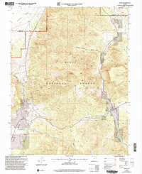
2002 Map of Pinto
USGS Topo · Published 2005About this map
Pinto stands at the eastern edge of this terrain, situated where the high desert of the Escalante Valley meets the rising slopes of the Dixie National Forest. This 2002 revision, based on earlier topographic data, illustrates a landscape defined by deep drainages like Wheat Grass Canyon and Holt Canyon, which carve through the volcanic and sedimentary formations of Cove Mountain. The distribution of water sources is critical to the area's history, marked by numerous named points such as Oak Spring, Cove Spring, and Hamblin Spring.
Find a feature on this map
22 named features on this map. Tap any name to fly to it.
Don’t see what you’re looking for? This feature index may not catch every label — zoom into the map to look around manually.
Map Details
Editions of this 2002 Pinto Map
This is the sole edition of this map. No revisions or reprints were ever made.
Other maps of this area

1885 · St. George
USGS Topo · 1:250,000

1891 · St. George
USGS Topo · 1:250,000

1950 · Iron Mountain
USGS Topo · 1:62,500

1950 · Silver Peak
USGS Topo · 1:24,000

1950 · Page Ranch
USGS Topo · 1:24,000

1951 · Silver Peak
USGS Topo · 1:24,000

1951 · Page Ranch
USGS Topo · 1:24,000

1953 · Cedar City
USGS Topo · 1:250,000

1957 · New Harmony
USGS Topo · 1:62,500

1958 · Cedar City
USGS Topo · 1:250,000