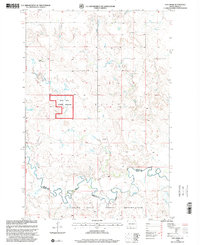
1998 Map of Pitt Creek
USGS Topo · Published 2001About this map
Standing Rock Indian Reservation dominates the southern landscape of this high plains region, where the boundary between Grant and Sioux counties follows the meandering course of Cedar Creek. The terrain is defined by a dense network of intermittent drainages, including Pitt Creek, Crooked Creek, and Timber Creek, which carve through the plateaus of Schultz and Winona. This map documents a sparsely populated ranching environment during the late 1990s, where traditional land use is represented by numerous Windmill sites scattered across the grazing lands. A significant portion of the western territory is designated as the Cedar River National Grassland, reflecting federal conservation and land management efforts in the North Dakota badlands. The Twelfth Guide Meridian and landmarks such as the E Texler Ranch provide essential points of orientation for researchers and genealogists tracing family land holdings in this remote corner of the state.
Find a feature on this map
13 named features on this map. Tap any name to fly to it.
Don’t see what you’re looking for? This feature index may not catch every label — zoom into the map to look around manually.
Map Details
Editions of this 1998 Pitt Creek Map
This is the sole edition of this map. No revisions or reprints were ever made.
Other maps of this area

1953 · McIntosh
USGS Topo · 1:250,000

1954 · Bismarck
USGS Topo · 1:250,000

1958 · Bismarck
USGS Topo · 1:250,000

1958 · McIntosh
USGS Topo · 1:250,000

1971 · Lookout Butte
USGS Topo · 1:24,000

1972 · Paradise Flats
USGS Topo · 1:24,000

1972 · Wheeler Hills
USGS Topo · 1:24,000

1972 · Morristown
USGS Topo · 1:24,000

1972 · Watauga
USGS Topo · 1:24,000

1972 · Hump Butte
USGS Topo · 1:24,000