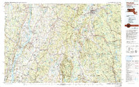
1986 Map of Pittsfield
USGS Topo · Published 1993About this map
The Taconic Range and Berkshire Hills dominate this regional landscape, creating a dramatic corridor of ridges and valleys where the borders of New York, Massachusetts, and Connecticut converge. During the mid-1980s, the area remained a patchwork of protected woodlands and historic industrial sites, such as Richmond Furnace. The transportation network is anchored by the Hudson River to the west and the Housatonic River winding through the eastern valley, supported by the Boston and Albany RR and the Taconic State Parkway.
Find a feature on this map
97 named features on this map. Tap any name to fly to it.
Don’t see what you’re looking for? This feature index may not catch every label — zoom into the map to look around manually.
Map Details
Editions of this 1986 Pittsfield Map
2 editions found
Other maps of this area

1885 · Sheffield
USGS Topo · 1:62,500

1886 · Greylock
USGS Topo · 1:62,500

1886 · Hawley
USGS Topo · 1:62,500

1886 · Chesterfield
USGS Topo · 1:62,500

1886 · Becket
USGS Topo · 1:62,500

1887 · Granville
USGS Topo · 1:62,500

1888 · Sheffield
USGS Topo · 1:62,500

1888 · Becket
USGS Topo · 1:62,500

1888 · Berlin
USGS Topo · 1:62,500

1888 · Sandisfield
USGS Topo · 1:62,500