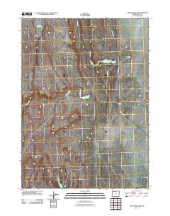
2011 Map of Piute Reservoir
USGS Topo · Published 2011About this map
Piute Reservoir and its surrounding drainage basin define this high-desert portion of Lake County in the early twenty-first century. The landscape is shaped by the management of water in an arid environment, where Piute Creek and Jack Creek feed into a system of man-made catchments including Barry Reservoir and Little Reservoir. This reliance on water storage reflects the agricultural and ranching heritage of the region, anchored by operations like Barry Ranch and Doherty Ranch. Access to these remote holdings is provided by routes such as Jack Creek Rd and the utilitarian B L M Road 8108A, highlighting the role of the Bureau of Land Management in maintaining the infrastructure of the Oregon backcountry.
Find a feature on this map
9 named features on this map. Tap any name to fly to it.
Don’t see what you’re looking for? This feature index may not catch every label — zoom into the map to look around manually.
Map Details
Editions of this 2011 Piute Reservoir Map
This is the sole edition of this map. No revisions or reprints were ever made.
Other maps of this area

1889 · Long Valley
USGS Topo · 1:250,000

1954 · Vya
USGS Topo · 1:250,000

1955 · Adel
USGS Topo · 1:250,000

1957 · Adel
USGS Topo · 1:250,000

1958 · Vya
USGS Topo · 1:250,000

1958 · Adel
USGS Topo · 1:250,000

1962 · Vya
USGS Topo · 1:250,000

1962 · Adel
USGS Topo · 1:250,000

1966 · Catnip Canyon
USGS Topo · 1:24,000
1966 · Rye Creek
USGS Topo · 1:24,000