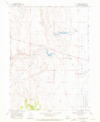
1968 Map of Piute Reservoir
USGS Topo · Published 1971About this map
Guano Valley and the surrounding high desert of Lake County are defined by a network of seasonal water management and remote ranching outposts in this late 1960s topographic study. The landscape is punctuated by essential catchments such as Piute Reservoir and Barry Reservoir, which capture the intermittent flows of Piute Creek and Jack Creek to support the local livestock economy. Settlements are sparse, represented by isolated landmarks like Barry Ranch and Doherty Ranch, which serve as the primary human touchpoints in this arid environment. A significant portion of the southeastern quadrant is dedicated to the Charles Sheldon Antelope Range, indicating the region's importance for wildlife conservation and land management. The presence of numerous Jeep Trails and a localized Borrow Pit suggests a pattern of movement and maintenance necessary to sustain these remote ranching operations across the high basin terrain.
Find a feature on this map
13 named features on this map. Tap any name to fly to it.
Don’t see what you’re looking for? This feature index may not catch every label — zoom into the map to look around manually.
Map Details
Editions of this 1968 Piute Reservoir Map
This is the sole edition of this map. No revisions or reprints were ever made.
Other maps of this area

1889 · Long Valley
USGS Topo · 1:250,000

1954 · Vya
USGS Topo · 1:250,000

1955 · Adel
USGS Topo · 1:250,000

1957 · Adel
USGS Topo · 1:250,000

1958 · Vya
USGS Topo · 1:250,000

1958 · Adel
USGS Topo · 1:250,000

1962 · Vya
USGS Topo · 1:250,000

1962 · Adel
USGS Topo · 1:250,000

1966 · Catnip Canyon
USGS Topo · 1:24,000
1966 · Rye Creek
USGS Topo · 1:24,000