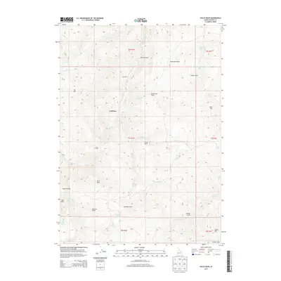
2013 Map of Pixley Basin
USGS Topo · Published 2013About this map
Gordy Ranch and Crill Place anchor this portion of Owyhee County, reflecting a landscape defined by scattered ranching operations and water access. The terrain is characterized by a series of high basins and sharp relief, most notably Pixley Basin and the Reservation Basin, which are separated by prominent landmarks like Black Butte and Toy Mtn. This high-desert environment relies on a network of intermittent creeks and vital water sources such as Goodman Gulch Spring, Portland Gulch Spring, and Lower Hogpen Spring, which have long dictated the movement of people and livestock across the range. A sparse network of trails and roads connects historic points like Savage Crossing and Squaw Gardens, illustrating the logistical challenges of the high country. The map traces the drainage patterns of Castle Cr, Pixley Cr, and Birch Cr, showing how the gulches and peaks of the Owyhee Front have shaped local geography.
Find a feature on this map
42 named features on this map. Tap any name to fly to it.
Don’t see what you’re looking for? This feature index may not catch every label — zoom into the map to look around manually.
Map Details
Editions of this 2013 Pixley Basin Map
This is the sole edition of this map. No revisions or reprints were ever made.
Other maps of this area

1955 · Jordan Valley
USGS Topo · 1:250,000

1957 · Jordan Valley
USGS Topo · 1:250,000

1958 · Jordan Valley
USGS Topo · 1:250,000

1965 · Triangle
USGS Topo · 1:62,500
1972 · Rough Mountain NE
USGS Topo · 1:24,000
1972 · Rough Mountain
USGS Topo · 1:24,000
1972 · Pixley Basin
USGS Topo · 1:24,000
1972 · Antelope Spring
USGS Topo · 1:24,000
1972 · Snow Creek
USGS Topo · 1:24,000
1972 · Clover Mtn
USGS Topo · 1:24,000