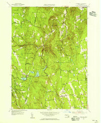
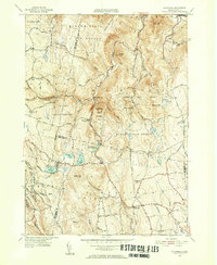
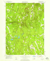
1955 Map of Plainfield
USGS Topo · Published 1956About this map
The northern Berkshires and the high ridges of Hampshire and Franklin counties converge here, defined by an intricate network of state forests and upland settlements. Plainfield sits as a central hub, connected to outlying hamlets like West Hawley and South Hawley via winding mountain roads. The landscape is dominated by the sprawling reaches of the Mohawk Trail State Forest, Savoy State Forest, and Hawley State Forest, which preserve the rugged character of the Hoosac Range.
Find a feature on this map
83 named features on this map. Tap any name to fly to it.
Don’t see what you’re looking for? This feature index may not catch every label — zoom into the map to look around manually.
Map Details
Editions of this 1955 Plainfield Map
4 editions found
Historical Maps of Ashfield Through Time
170 maps found

1886 Hawley
Franklin County, MA

1887 Warwick
Franklin County, MA

1889 Warwick
Franklin County, MA

1890 Greenfield
Franklin County, MA

1890 Hawley
Franklin County, MA

1894 Greenfield
Franklin County, MA

1894 Hawley
Franklin County, MA

1894 Warwick
Franklin County, MA

1932 Warwick
Franklin County, MA

1935 Mount Toby
Franklin County, MA

1935 Warwick
Franklin County, MA

1935 Williamsburg
Franklin County, MA

1936 Bernardston
Franklin County, MA

1936 Greenfield
Franklin County, MA

1936 Northfield
Franklin County, MA

1937 Colrain
Franklin County, MA

1937 Mt Grace
Franklin County, MA

1937 Orange
Franklin County, MA

1941 Bernardston
Franklin County, MA

1941 Colrain
Franklin County, MA

1941 Greenfield
Franklin County, MA

1941 Mt Grace
Franklin County, MA

1941 Mt Toby
Franklin County, MA

1941 Northfield
Franklin County, MA

1941 Orange
Franklin County, MA

1941 Williamsburg
Franklin County, MA

1942 Shutesbury
Franklin County, MA

1943 Ashfield
Franklin County, MA

1943 Shutesbury
Franklin County, MA

1944 Mt Toby
Franklin County, MA

1944 Quabbin Reservoir
Franklin County, MA

1944 Rowe
Franklin County, MA

1945 Bernardston
Franklin County, MA

1945 Colrain
Franklin County, MA

1945 Heath
Franklin County, MA

1945 Mt Grace
Franklin County, MA

1945 Northfield
Franklin County, MA

1946 Bernardston
Franklin County, MA

1946 Colrain
Franklin County, MA

1946 Mt Grace
Franklin County, MA

1946 Northfield
Franklin County, MA

1947 Plainfield
Franklin County, MA

1947 Rowe
Franklin County, MA

1948 Orange
Franklin County, MA

1948 Plainfield
Franklin County, MA

1948 Williamsburg
Franklin County, MA

1950 Heath
Franklin County, MA

1950 Shutesbury
Franklin County, MA

1952 Quabbin Reservoir
Franklin County, MA

1954 Greenfield
Franklin County, MA

1955 Ashfield
Franklin County, MA

1955 Mt Toby
Franklin County, MA

1955 Plainfield
Franklin County, MA

1960 Rowe
Franklin County, MA

1961 Bernardston
Franklin County, MA

1961 Colrain
Franklin County, MA

1961 Heath
Franklin County, MA

1961 Mt Grace
Franklin County, MA

1961 Northfield
Franklin County, MA

1961 Orange
Franklin County, MA

1964 Shutesbury
Franklin County, MA

1964 Williamsburg
Franklin County, MA

1967 Quabbin Reservoir
Franklin County, MA

1968 Greenfield
Franklin County, MA

1971 Ashfield
Franklin County, MA

1971 Mt Toby
Franklin County, MA

1971 Plainfield
Franklin County, MA

1973 Rowe
Franklin County, MA

1974 Heath
Franklin County, MA

1975 Ashfield
Franklin County, MA

1975 Bernardston
Franklin County, MA

1975 Colrain
Franklin County, MA

1975 Greenfield
Franklin County, MA

1975 Heath
Franklin County, MA

1975 Mt Grace
Franklin County, MA

1975 Mt Toby
Franklin County, MA

1975 Northfield
Franklin County, MA

1975 Orange
Franklin County, MA

1975 Plainfield
Franklin County, MA

1975 Quabbin Reservoir
Franklin County, MA

1975 Rowe
Franklin County, MA

1975 Shutesbury
Franklin County, MA

1975 Williamsburg
Franklin County, MA

1977 Bernardston
Franklin County, MA

1977 Colrain
Franklin County, MA

1977 Mt Grace
Franklin County, MA

1977 Northfield
Franklin County, MA

1977 Orange
Franklin County, MA

1990 Ashfield
Franklin County, MA

1990 Bernardston
Franklin County, MA

1990 Greenfield
Franklin County, MA

1990 Northfield
Franklin County, MA

1990 Orange
Franklin County, MA

1990 Rowe
Franklin County, MA

1990 Shutesbury
Franklin County, MA

1990 Williamsburg
Franklin County, MA

1997 Rowe
Franklin County, MA

1998 Ashfield
Franklin County, MA

1998 Bernardston
Franklin County, MA

1998 Rowe
Franklin County, MA

2012 Ashfield
Franklin County, MA

2012 Bernardston
Franklin County, MA

2012 Colrain
Franklin County, MA

2012 Greenfield
Franklin County, MA

2012 Heath
Franklin County, MA

2012 Mount Grace
Franklin County, MA

2012 Mount Toby
Franklin County, MA

2012 Northfield
Franklin County, MA

2012 Orange
Franklin County, MA

2012 Plainfield
Franklin County, MA

2012 Quabbin Reservoir
Franklin County, MA

2012 Rowe
Franklin County, MA

2012 Shutesbury
Franklin County, MA

2012 Williamsburg
Franklin County, MA

2015 Ashfield
Franklin County, MA

2015 Bernardston
Franklin County, MA

2015 Colrain
Franklin County, MA

2015 Greenfield
Franklin County, MA

2015 Heath
Franklin County, MA

2015 Mount Grace
Franklin County, MA

2015 Mount Toby
Franklin County, MA

2015 Northfield
Franklin County, MA

2015 Orange
Franklin County, MA

2015 Plainfield
Franklin County, MA

2015 Quabbin Reservoir
Franklin County, MA

2015 Rowe
Franklin County, MA

2015 Shutesbury
Franklin County, MA

2015 Williamsburg
Franklin County, MA

2018 Ashfield
Franklin County, MA

2018 Bernardston
Franklin County, MA

2018 Colrain
Franklin County, MA

2018 Greenfield
Franklin County, MA

2018 Heath
Franklin County, MA

2018 Mount Grace
Franklin County, MA

2018 Mount Toby
Franklin County, MA

2018 Northfield
Franklin County, MA

2018 Orange
Franklin County, MA

2018 Plainfield
Franklin County, MA

2018 Quabbin Reservoir
Franklin County, MA

2018 Rowe
Franklin County, MA

2018 Shutesbury
Franklin County, MA

2018 Williamsburg
Franklin County, MA

2021 Ashfield
Franklin County, MA

2021 Bernardston
Franklin County, MA

2021 Colrain
Franklin County, MA

2021 Greenfield
Franklin County, MA

2021 Heath
Franklin County, MA

2021 Mount Grace
Franklin County, MA

2021 Mount Toby
Franklin County, MA

2021 Northfield
Franklin County, MA

2021 Orange
Franklin County, MA

2021 Plainfield
Franklin County, MA

2021 Quabbin Reservoir
Franklin County, MA

2021 Rowe
Franklin County, MA

2021 Shutesbury
Franklin County, MA

2021 Williamsburg
Franklin County, MA

2024 Ashfield
Franklin County, MA

2024 Bernardston
Franklin County, MA

2024 Colrain
Franklin County, MA

2024 Greenfield
Franklin County, MA

2024 Heath
Franklin County, MA

2024 Mount Grace
Franklin County, MA

2024 Mount Toby
Franklin County, MA

2024 Northfield
Franklin County, MA

2024 Orange
Franklin County, MA

2024 Plainfield
Franklin County, MA

2024 Quabbin Reservoir
Franklin County, MA

2024 Rowe
Franklin County, MA

2024 Shutesbury
Franklin County, MA

2024 Williamsburg
Franklin County, MA