
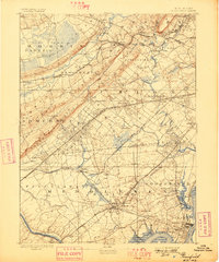
1893 Map of Plainfield
USGS Topo · Published 1893About this map
The Great Swamp dominates the northwestern corner of this landscape, a significant natural feature that shaped the early development patterns of Morris and Union counties. This 1887 survey, published in 1893, reveals a region in the midst of a railway-driven expansion, with lines like the Central Railroad of New Jersey and the Lehigh Valley Railroad carving through the countryside. These corridors spurred the growth of commuter hubs and industrial outposts alike, from the manufacturing at Stanley and Milltown to the residential clusters forming in Westfield and Summit.
Find a feature on this map
102 named features on this map. Tap any name to fly to it.
Don’t see what you’re looking for? This feature index may not catch every label — zoom into the map to look around manually.
Map Details
Editions of this 1893 Plainfield Map
2 editions found
Other maps of this area

1888 · Plainfield
USGS Topo · 1:62,500

1888 · Morristown
USGS Topo · 1:62,500

1888 · New Brunswick
USGS Topo · 1:62,500

1888 · Princeton
USGS Topo · 1:62,500

1888 · Lake Hopatcong
USGS Topo · 1:62,500

1888 · Paterson
USGS Topo · 1:62,500

1888 · Sandy Hook
USGS Topo · 1:62,500

1891 · Somerville
USGS Topo · 1:62,500

1892 · Paterson
USGS Topo · 1:62,500

1893 · New Brunswick
USGS Topo · 1:62,500