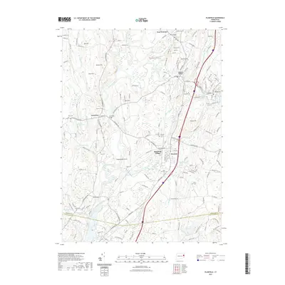
2021 Map of Plainfield
USGS Topo · Published 2021About this map
The Quinebaug River and Moosup River converge near Central Village, defining a landscape where industrial water power once dictated the placement of mill villages. This 2021 edition details the modern transportation corridors of Interstate 395 and the Plainfield Road as they bypass historical clusters like Plainfield Village and West Wauregan. For those tracing local heritage, the map identifies numerous burial grounds including the Old Plainfield Cemetery and Packerville Cemetery, alongside named family landmarks like Shepherd Hill and Holmes Hill. The inclusion of the Quinebaug Trail and Pachaug Forest Trail illustrates the transition of the riverbanks from strictly industrial use to recreational conservation. This survey serves as a contemporary record of the border between Windham and New London counties, marking the persistent footprint of long-standing settlements like Canterbury amidst modern infrastructure development.
Find a feature on this map
60 named features on this map. Tap any name to fly to it.
Don’t see what you’re looking for? This feature index may not catch every label — zoom into the map to look around manually.
Map Details
Editions of this 2021 Plainfield Map
This is the sole edition of this map. No revisions or reprints were ever made.
Other maps of this area

1889 · Putnam
USGS Topo · 1:62,500

1889 · Moosup
USGS Topo · 1:62,500

1892 · Woodstock
USGS Topo · 1:62,500

1892 · Norwich
USGS Topo · 1:62,500

1893 · Putnam
USGS Topo · 1:62,500

1893 · Moosup
USGS Topo · 1:62,500

1919 · Putnam
USGS Topo · 1:62,500

1920 · Moosup
USGS Topo · 1:62,500

1921 · Woodstock
USGS Topo · 1:62,500
1943 · Voluntown
USGS Topo · 1:31,680