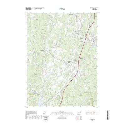
2023 Map of Plainfield
USGS Topo · Published 2023About this map
Plainfield Village and Moosup anchor this portrait of the Quinebaug River valley, where industrial-era hamlets follow the water's edge. The landscape is dense with genealogical landmarks, particularly family and church burial grounds like the Tillinghast Memorial Cem and the Joseph Roode Farm Cem, illustrating the deep-rooted agrarian and early manufacturing history of eastern Connecticut. The Quinebaug River winds through the center of the sheet, widening into Aspinook Pond and passing Peagscomsuck Island near the cluster of Central Village. To the west, the more rural township of Canterbury is defined by a series of prominent rises including Morgan Hill and Black Hill. This recent survey details the modern suburban density superimposed over the historic textile mill corridor that originally shaped settlements like Wauregan and Clayville.
Find a feature on this map
69 named features on this map. Tap any name to fly to it.
Don’t see what you’re looking for? This feature index may not catch every label — zoom into the map to look around manually.
Map Details
Editions of this 2023 Plainfield Map
This is the sole edition of this map. No revisions or reprints were ever made.
Other maps of this area

1889 · Putnam
USGS Topo · 1:62,500

1889 · Moosup
USGS Topo · 1:62,500

1892 · Woodstock
USGS Topo · 1:62,500

1892 · Norwich
USGS Topo · 1:62,500

1893 · Putnam
USGS Topo · 1:62,500

1893 · Moosup
USGS Topo · 1:62,500

1919 · Putnam
USGS Topo · 1:62,500

1920 · Moosup
USGS Topo · 1:62,500

1921 · Woodstock
USGS Topo · 1:62,500
1943 · Voluntown
USGS Topo · 1:31,680