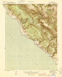
1944 Map of Plantation
USGS Topo · Published 1944About this map
Kruse Rhododendron Reserve State Park sits at the heart of this Sonoma coast survey, surrounded by a complex network of coastal gulches and ridges during the mid-1940s. The settlement at Plantation is the primary inland hub, supported by the nearby Plantation Sch. The geography is defined by the sharp transition from the Pacific Ocean to the timber-covered uplands, where the South Fork Gualala River and its many tributaries like Sproule Creek and Haupt Creek drain the landscape.
Find a feature on this map
31 named features on this map. Tap any name to fly to it.
Don’t see what you’re looking for? This feature index may not catch every label — zoom into the map to look around manually.
Map Details
Editions of this 1944 Plantation Map
2 editions found
Other maps of this area

1921 · Skaggs
USGS Topo · 1:62,500

1921 · Plantation
USGS Topo · 1:62,500

1942 · Arched Rock
USGS Topo · 1:24,000

1943 · Tombs Creek
USGS Topo · 1:24,000

1943 · Stewarts Point
USGS Topo · 1:24,000

1943 · Plantation
USGS Topo · 1:24,000

1943 · Annapolis
USGS Topo · 1:24,000

1943 · Fort Ross
USGS Topo · 1:24,000
1944 · Fort Ross
USGS Topo · 1:31,680

1944 · Annapolis
USGS Topo · 1:31,680