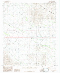
1986 Map of Platt Well
USGS Topo · Published 1986About this map
Luke Air Force Range dominates this landscape in Maricopa County, highlighting the significant military footprint in the Arizona desert during the mid-1980s. The terrain is defined by the sharp elevations of the Sand Tank Mountains to the northeast and the Sauceda Mountains in the south, separated by an expanse of arid basins. Water management in this dry environment is evident through features like Pottebaum Tank and the namesake Platt Well, which provided essential resources for land use prior to and during the range's establishment. Seasonal drainage patterns are clearly marked by the Quilotosa Wash and Sauceda Wash, which cut through the sandy flats between the mountain ranges, illustrating the natural hydrological network of the Sonoran desert floor.
Find a feature on this map
9 named features on this map. Tap any name to fly to it.
Don’t see what you’re looking for? This feature index may not catch every label — zoom into the map to look around manually.
Map Details
Editions of this 1986 Platt Well Map
This is the sole edition of this map. No revisions or reprints were ever made.
Other maps of this area

1951 · Estrella
USGS Topo · 1:62,500

1951 · Gila Bend
USGS Topo · 1:62,500

1953 · Ajo
USGS Topo · 1:250,000

1957 · Ajo
USGS Topo · 1:250,000

1958 · Ajo
USGS Topo · 1:250,000

1958 · Kaka
USGS Topo · 1:62,500

1958 · Hat Mountain
USGS Topo · 1:62,500

1962 · Ajo
USGS Topo · 1:250,000

1963 · Ajo
USGS Topo · 1:250,000

1967 · Ajo
USGS Topo · 1:250,000