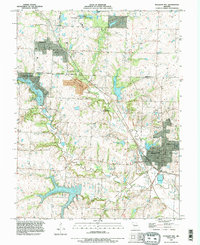
1990 Map of Pleasant Hill
USGS Topo · Published 1995About this map
Pleasant Hill and Greenwood anchor this survey of the northern Cass County and southern Jackson County line during the 1990s. The landscape is defined by an extensive network of water resources, from the northern James A Reed Memorial State Wildlife Area to the sprawling Harrisonville City Lake in the south. The area around Lake Winnebago shows specialized development, including the Lake Winnebago Landing Strip, reflecting the mid-century growth of residential and recreational communities.
Find a feature on this map
36 named features on this map. Tap any name to fly to it.
Don’t see what you’re looking for? This feature index may not catch every label — zoom into the map to look around manually.
Map Details
Editions of this 1990 Pleasant Hill Map
This is the sole edition of this map. No revisions or reprints were ever made.
Other maps of this area

1887 · Harrisonville
USGS Topo · 1:125,000

1892 · Harrisonville
USGS Topo · 1:125,000

1894 · Harrisonville
USGS Topo · 1:125,000

1934 · Lees Summit
USGS Topo · 1:24,000

1934 · Woods Chapel
USGS Topo · 1:24,000

1935 · Tarsney
USGS Topo · 1:24,000

1939 · Lees Summit
USGS Topo · 1:31,680

1947 · Lawrence
USGS Topo · 1:250,000
1949 · Lees Summit
USGS Topo · 1:24,000

1950 · Lawrence
USGS Topo · 1:250,000