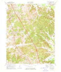
1973 Map of Pleasant Ridge
USGS Topo · Published 1974About this map
Oil fields and scattered oil wells define the industrial footprint of this western Kentucky landscape, where the boundary between Daviess and Ohio counties cuts through a series of creek valleys. Small rural settlements like Pleasant Ridge and Bells Run serve as anchors for a community of country churches and family burial grounds, including Bells Run Ch and Dodson Cem. The southern edge of the sheet is dominated by the winding course of the Rough River, which flows past landmarks like Whoopee Hill and Crooked Pond. The transport network of the early 1970s is well-documented, showing the transition from paved routes to rural paths such as Girl Scout Rd and Ferry Road. This survey provides a clear look at the region's topography, from the heights of Hoover Hill to the wetlands along South Fork Panther Creek.
Find a feature on this map
51 named features on this map. Tap any name to fly to it.
Don’t see what you’re looking for? This feature index may not catch every label — zoom into the map to look around manually.
Map Details
Editions of this 1973 Pleasant Ridge Map
This is the sole edition of this map. No revisions or reprints were ever made.
Other maps of this area

1906 · Sutherland
USGS Topo · 1:62,500

1907 · Whitesville
USGS Topo · 1:62,500

1909 · Whitesville
USGS Topo · 1:62,500

1909 · Hartford
USGS Topo · 1:62,500

1909 · Central City
USGS Topo · 1:62,500

1952 · Equality
USGS Topo · 1:24,000

1953 · Philpot
USGS Topo · 1:24,000

1953 · Sutherland
USGS Topo · 1:24,000

1953 · Utica
USGS Topo · 1:24,000

1953 · Dundee
USGS Topo · 1:24,000