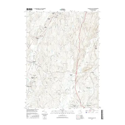
2016 Map of Pleasant Valley
USGS Topo · Published 2016About this map
Wappinger Creek and Sprout Creek anchor the landscape of central Dutchess County, where suburban development intermingles with older rural settlements. The area shows a distinct pattern of residential expansion, seen in neighborhoods like Timothy Heights, Clark Heights, and Colonial Heights that sit between the primary corridors of Main St and the Taconic State Pkwy. Local history and genealogy are anchored in several burial grounds, including Saint Paul's Episcopal Cem and the Pleasant Valley Presbyterian Cem in Pleasant Valley. Transport networks are prominently featured, with the parkway cutting through the eastern half of the map near Freedom Plains, while older crossing points like Manchester Bridge and Montfor Bridge remain vital local landmarks. The transition from the more developed Rochdale area toward the eastern hills near Sunset Hill and Moores Mill reflects the region's evolving land use from traditional milling to modern residential life.
Find a feature on this map
194 named features on this map. Tap any name to fly to it.
Don’t see what you’re looking for? This feature index may not catch every label — zoom into the map to look around manually.
Map Details
Editions of this 2016 Pleasant Valley Map
This is the sole edition of this map. No revisions or reprints were ever made.
Other maps of this area

1893 · Clove
USGS Topo · 1:62,500

1893 · Poughkeepsie
USGS Topo · 1:62,500

1894 · Clove
USGS Topo · 1:62,500

1894 · Poughkeepsie
USGS Topo · 1:62,500

1898 · Clove
USGS Topo · 1:62,500

1898 · Rhinebeck
USGS Topo · 1:62,500

1899 · Millbrook
USGS Topo · 1:62,500

1901 · Clove
USGS Topo · 1:62,500

1902 · Millbrook
USGS Topo · 1:62,500

1903 · Poughkeepsie
USGS Topo · 1:62,500