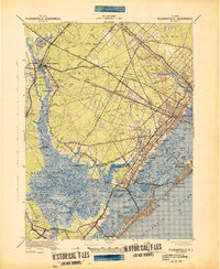
1943 Map of Pleasantville
USGS Topo · Published 1943About this map
The Great Egg Harbor River serves as the central artery for this coastal New Jersey landscape, winding through Griscoms Swamp and past the inland settlement of Mays Landing. The 1943 War Department survey reveals a transition from these dense woodlands and wetlands to the developing bayside communities. The transportation network is defined by the Pennsylvania Reading Seashore Lines and the Black Horse Pike, which facilitated the growth of centers like Pleasantville and Absecon.
Find a feature on this map
103 named features on this map. Tap any name to fly to it.
Don’t see what you’re looking for? This feature index may not catch every label — zoom into the map to look around manually.
Map Details
Editions of this 1943 Pleasantville Map
This is the sole edition of this map. No revisions or reprints were ever made.
Other maps of this area

1884 · Sea Isle
USGS Topo · 1:62,500

1887 · Atlantic City
USGS Topo · 1:62,500

1888 · Dennisville
USGS Topo · 1:62,500

1888 · Little Egg Harbor
USGS Topo · 1:62,500

1888 · Sea Isle
USGS Topo · 1:62,500

1890 · Great Egg Harbor
USGS Topo · 1:62,500

1890 · Hammonton
USGS Topo · 1:62,500

1890 · Tuckahoe
USGS Topo · 1:62,500

1890 · Mullica
USGS Topo · 1:62,500

1893 · Great Egg Harbor
USGS Topo · 1:62,500