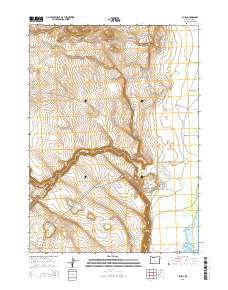
2014 Map of Plush
USGS Topo · Published 2014About this map
Plush sits at the base of the dramatic Fish Creek Rim within the high desert landscape of Warner Valley. This 2014 survey reveals a ranching landscape where local travel is defined by long, straight stretches like the Plush Cut Off RD and Hogback RD. The topography is marked by significant elevation changes, with numerous draws such as Juniper Spring Draw and Miners Draw cutting through the western ridges. Water remains a critical element of this arid terrain, with Honey Cr and Twomile Cr feeding toward the basin of Hart Lake on the eastern edge of the quadrangle. Local land ownership is grounded in family names, evidenced by the Snyder Rnch to the north and Taylor Ranch Ln near the center of the settlement. The map provides a clear record of the rural infrastructure connecting these points, from the Plush-Adel RD to the local Hart Mountain RD.
Find a feature on this map
23 named features on this map. Tap any name to fly to it.
Don’t see what you’re looking for? This feature index may not catch every label — zoom into the map to look around manually.
Map Details
Editions of this 2014 Plush Map
This is the sole edition of this map. No revisions or reprints were ever made.
Other maps of this area

1955 · Klamath Falls
USGS Topo · 1:250,000

1955 · Adel
USGS Topo · 1:250,000

1957 · Adel
USGS Topo · 1:250,000

1958 · Klamath Falls
USGS Topo · 1:250,000

1958 · Adel
USGS Topo · 1:250,000

1962 · Adel
USGS Topo · 1:250,000

1967 · Flagstaff Lake
USGS Topo · 1:24,000

1967 · Plush
USGS Topo · 1:24,000

1967 · Rabbit Hills SW
USGS Topo · 1:24,000

1967 · Priday Reservoir
USGS Topo · 1:24,000