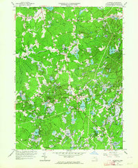
1962 Map of Plympton
USGS Topo · Published 1964About this map
Cranberry Bogs dominate the low-lying wetlands of this Plymouth County landscape, illustrating the region's specialized agricultural heritage in the early 1960s. The town of Plympton serves as a central hub, surrounded by smaller historical clusters like Eddyville, Waterville, and Harrubs Corner. Water defines the geography, from the expansive Monponsett Pond in the north to the Winnetuxet River and numerous smaller basins such as Muddy Pond and Wenham Pond. Local genealogy is well-supported by the presence of Lakenham Cem, Thomastown Cem, and the Carver Sch. The map reveals a network of established country roads, including Wapping Road, Mayflower Road, and Purchase Street, connecting scattered farmsteads and rural crossroads. The southern portion includes portions of the State Forest and the community of Carver, where the landscape transitions into the dense thickets of Cedar Swamp.
Find a feature on this map
91 named features on this map. Tap any name to fly to it.
Don’t see what you’re looking for? This feature index may not catch every label — zoom into the map to look around manually.
Map Details
Editions of this 1962 Plympton Map
2 editions found
Other maps of this area

1885 · Abington
USGS Topo · 1:62,500

1885 · Duxbury
USGS Topo · 1:62,500

1885 · Middleboro
USGS Topo · 1:62,500

1886 · Plymouth
USGS Topo · 1:62,500

1888 · Duxbury
USGS Topo · 1:62,500

1888 · Middleboro
USGS Topo · 1:62,500

1888 · Abington
USGS Topo · 1:62,500

1889 · Plymouth
USGS Topo · 1:62,500

1893 · Abington
USGS Topo · 1:62,500

1893 · Duxbury
USGS Topo · 1:62,500