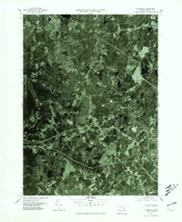
1977 Map of Plympton
USGS Topo · Published 1981About this map
Plympton and its surrounding agricultural and woodland parcels define this late-1970s orthophotoquad, captured at a moment when traditional land patterns remained clearly visible from above. The drainage of the Winnetuxet River and Jones River provides the primary structure for the landscape, influencing the placement of early settlements like Halifax and Eddyville. Unlike a traditional topographic map, this imagery-based survey reveals the specific texture of the Massachusetts interior, from the dense forest cover near Carver to the cleared fields and residential clusters in North Carver and Wenham. This perspective offers a genuine look at property boundaries and land use before subsequent decades of suburban expansion, making it a valuable tool for tracking the evolution of Plymouth County’s rural character.
Find a feature on this map
10 named features on this map. Tap any name to fly to it.
Don’t see what you’re looking for? This feature index may not catch every label — zoom into the map to look around manually.
Map Details
Editions of this 1977 Plympton Map
4 editions found
Other maps of this area

1885 · Abington
USGS Topo · 1:62,500

1885 · Duxbury
USGS Topo · 1:62,500

1885 · Middleboro
USGS Topo · 1:62,500

1886 · Plymouth
USGS Topo · 1:62,500

1888 · Duxbury
USGS Topo · 1:62,500

1888 · Middleboro
USGS Topo · 1:62,500

1888 · Abington
USGS Topo · 1:62,500

1889 · Plymouth
USGS Topo · 1:62,500

1893 · Abington
USGS Topo · 1:62,500

1893 · Duxbury
USGS Topo · 1:62,500