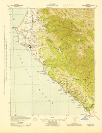
1943 Map of Point Arena
USGS Topo · Published 1943About this map
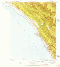
Dairy ranching and coastal logging dominate this Mendocino County landscape, where the Garcia River reaches the Pacific. The coastline is marked by a series of landings and points, including Point Arena and the small settlement of Manchester. Family operations are evident throughout the hinterland, from the Hillcrest Dairy and A Stronetta Ranch to the Bourns Family Cem near the southern border. The presence of the Iverson Indian Rancheria and several schools like Seaside School indicate the established community structure during this era.
Find a feature on this map
117 named features on this map. Tap any name to fly to it.
Don’t see what you’re looking for? This feature index may not catch every label — zoom into the map to look around manually.
Map Details
Editions of this 1943 Point Arena Map
2 editions found

Other maps of this area

1921 · Plantation
USGS Topo · 1:62,500
1943 · Albion
USGS Topo · 1:62,500
1943 · Boonville
USGS Topo · 1:62,500
1943 · Navarro
USGS Topo · 1:62,500
1943 · Stewarts Point
USGS Topo · 1:24,000

1943 · Ornbaun
USGS Topo · 1:62,500

1944 · Stewarts Point
USGS Topo · 1:31,680

1944 · Saddle Point
USGS Topo · 1:62,500

1944 · Ornbaun
USGS Topo · 1:62,500

1947 · Santa Rosa
USGS Topo · 1:250,000