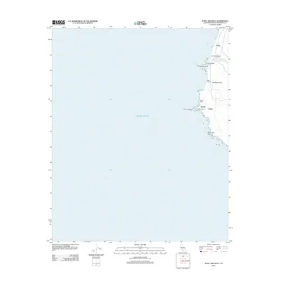
2012 Map of Point Arguello
USGS Topo · Published 2012About this map
Point Arguello Lighthouse stands as a sentinel on this treacherous stretch of the California coast, overlooking the vast Pacific Ocean. This survey captures the coastline north of Santa Barbara as it appeared in the early 21st century, dominated by the railroad corridor and the rugged marine geography. The small settlements of Honda, Arguello, and Arlight mark the transition between the coastal bluffs and the interior canyons. The maritime history of the region is etched into the landscape at Destroyer Rock and Point Pedernales, sites infamous for historical shipwrecks. Inland, the terrain is defined by deep incisions like La Honda Canyon and Red Roof Canyon, which drain toward the shore. This map provides a detailed view of the infrastructure and landforms of this isolated coastal reach, where the rail line hugs the cliffs above Rocky Point.
Find a feature on this map
15 named features on this map. Tap any name to fly to it.
Don’t see what you’re looking for? This feature index may not catch every label — zoom into the map to look around manually.
Map Details
Editions of this 2012 Point Arguello Map
This is the sole edition of this map. No revisions or reprints were ever made.
Other maps of this area

1905 · Guadalupe
USGS Topo · 1:125,000

1942 · Point Arguello
USGS Topo · 1:62,500

1942 · Guadalupe
USGS Topo · 1:125,000

1947 · Surf
USGS Topo · 1:24,000
1947 · El Tranquillon
USGS Topo · 1:24,000
1947 · Point Arguello
USGS Topo · 1:62,500
1948 · Point Arguello
USGS Topo · 1:24,000
1948 · El Tranquillon
USGS Topo · 1:24,000

1948 · Santa Maria
USGS Topo · 1:250,000

1956 · Santa Maria
USGS Topo · 1:250,000