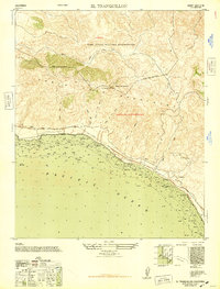
1948 Map of El Tranquillon
USGS Topo · Published 1948About this map
Tranquillon Mountain dominates this coastal stretch of the Santa Ynez Mountains, where steep ridgelines descend toward the Pacific Ocean. This 1947 compilation reflects a landscape shaped by wartime defense and early post-war military activity, most notably through the Camp Cooke Military Reservation and a U. S. Naval Radar Station perched on the heights. The Southern Pacific railroad follows the shoreline precisely, connecting small trackside points such as Arguello, Sudden, and The Espada. The terrain is deeply incised by numerous canyons, or cañadas, including Cañada de la Honda and Cañada del Cojo, which drain the southern slopes of the range. Hydrographic data along the coast provides detail on the rocky shoreline at Punta de la Concepcion, marking a significant point of navigation for maritime traffic along the California coast.
Find a feature on this map
21 named features on this map. Tap any name to fly to it.
Don’t see what you’re looking for? This feature index may not catch every label — zoom into the map to look around manually.
Map Details
Editions of this 1948 El Tranquillon Map
This is the sole edition of this map. No revisions or reprints were ever made.
Other maps of this area

1905 · Guadalupe
USGS Topo · 1:125,000

1905 · Lompoc
USGS Topo · 1:125,000

1942 · Point Arguello
USGS Topo · 1:62,500

1942 · Guadalupe
USGS Topo · 1:125,000

1942 · Lompoc
USGS Topo · 1:125,000

1942 · Lompoc
USGS Topo · 1:62,500

1942 · Pt. Conception
USGS Topo · 1:62,500

1943 · Lompoc
USGS Topo · 1:125,000

1947 · Lompoc
USGS Topo · 1:24,000

1947 · Surf
USGS Topo · 1:24,000