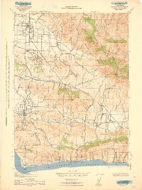
1943 Map of Lompoc
USGS Topo · Published 1943About this map
Santa Maria Valley and the surrounding coastal ranges appear here during the height of World War II, showing a landscape defined by its deep Spanish heritage and agricultural development. The presence of Mission La Purisima and Santa Ynez Mission anchors the map in its colonial history, while the 20th-century economy is represented by the Pacific Coast Railroad and the Asphaltum Mine in the hills north of Los Olivos. The coastline from Pt Conception to Orella is dominated by the Southern Pacific line, which follows the narrow shelf between the Santa Rosa Hills and the Santa Barbara Channel.
Find a feature on this map
136 named features on this map. Tap any name to fly to it.
Don’t see what you’re looking for? This feature index may not catch every label — zoom into the map to look around manually.
Map Details
Editions of this 1943 Lompoc Map
This is the sole edition of this map. No revisions or reprints were ever made.
Other maps of this area

1897 · Arroyo Grande
USGS Topo · 1:62,500

1900 · San Luis
USGS Topo · 1:125,000

1902 · Santa Ynez
USGS Topo · 1:125,000

1905 · Guadalupe
USGS Topo · 1:125,000

1905 · Santa Ynez
USGS Topo · 1:125,000

1905 · Lompoc
USGS Topo · 1:125,000

1912 · McKittrick
USGS Topo · 1:125,000

1922 · Nipomo
USGS Topo · 1:62,500

1937 · Branch Mtn
USGS Topo · 1:48,000
1941 · San Rafael Mtn.
USGS Topo · 1:62,500