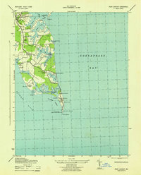
1943 Map of Point Lookout
USGS Topo · Published 1943About this map
Point Lookout Lighthouse stands at the southernmost tip of the St. Mary’s peninsula, guarding the confluence of the Potomac River and the Chesapeake Bay. During this wartime era, the peninsula’s strategic location is evident through the presence of the Point Lookout U S Coast Guard Reservation and military installations like Camp Ernest W Brown. The map reveals a landscape defined by deeply indented tidal prongs and creeks, such as St Jerome Creek and Lookout Creek, which create isolated necks of land like Fresh Pond Neck and Long Neck.
Find a feature on this map
53 named features on this map. Tap any name to fly to it.
Don’t see what you’re looking for? This feature index may not catch every label — zoom into the map to look around manually.
Map Details
Editions of this 1943 Point Lookout Map
This is the sole edition of this map. No revisions or reprints were ever made.
Other maps of this area

1894 · Point Lookout
USGS Topo · 1:62,500

1898 · St. Marys
USGS Topo · 1:125,000

1903 · Bloodsworth Island
USGS Topo · 1:62,500

1906 · St. Marys
USGS Topo · 1:125,000

1912 · Point Lookout
USGS Topo · 1:62,500

1917 · Heathsville
USGS Topo · 1:48,000

1917 · Ewell
USGS Topo · 1:62,500

1937 · Point Lookout
USGS Topo · 1:62,500

1942 · Richland Point
USGS Topo · 1:24,000
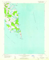
1942 · Point Lookout
USGS Topo · 1:24,000