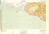
1950 Map of Point Mugu
USGS Topo · Published 1950About this map
Point Mugu Naval Reservation dominates the western coastal flats where the Rio De Santa Clara meets the salt marshes of the Mugu Lagoon. This 1950 edition shows a landscape defined by the sharp transition between the military presence on the plain and the wilder slopes of the Santa Monica Mountains. Coastal travelers of the era navigated the winding Roosevelt Highway as it hugged the shoreline beneath Point Mugu, passing a solitary quarry and several family-named landmarks like Laguna Point. The interior terrain is deeply etched by canyons such as Big Sycamore Canyon and Serrano Canyon, where small springs and a windmill indicate the scattered infrastructure of the foothill valleys. To the north, the agrarian influence is visible in the Duck Ponds and the irrigation network surrounding Calleguas Creek.
Find a feature on this map
22 named features on this map. Tap any name to fly to it.
Don’t see what you’re looking for? This feature index may not catch every label — zoom into the map to look around manually.
Map Details
Editions of this 1950 Point Mugu Map
This is the sole edition of this map. No revisions or reprints were ever made.
Other maps of this area

1900 · Triunfo Pass
USGS Topo · 1:62,500

1903 · Camulos
USGS Topo · 1:125,000

1904 · Hueneme
USGS Topo · 1:62,500

1921 · Triunfo Pass
USGS Topo · 1:62,500

1932 · Arroyo Sequit
USGS Topo · 1:24,000

1942 · Hueneme
USGS Topo · 1:62,500

1943 · Hueneme
USGS Topo · 1:62,500
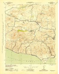
1943 · Triunfo Pass
USGS Topo · 1:62,500

1949 · Los Angeles
USGS Topo · 1:250,000

1949 · Oxnard
USGS Topo · 1:24,000