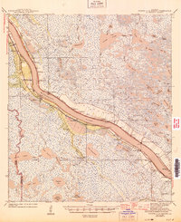
1944 Map of Pointe a La Hache
USGS Topo · Published 1944About this map
The Mississippi River defines the human and economic landscape of this coastal region, where narrow strips of inhabited land give way to the sprawling marshlands of Plaquemines Parish. Along the river's levees, the Missouri Pacific and Louisiana Southern railroads facilitate movement between numerous small settlements and plantation sites. Notable locales like Pointe a la Hache and Phoenix serve as hubs amidst a network of canals and bayous. The map reveals the intricate water systems of the delta, including Grand Lake and Aux Chenes River, which dominate the eastern wetlands. Cultural markers such as the Deer Range Cem and St Jude Sch provide essential points of reference for genealogists tracing family roots in these river communities during the early 1940s. The transition from established riverbank towns like Myrtle Grove to the interior bayou country illustrates the historic dependence on both rail and water transport in southern Louisiana.
Find a feature on this map
114 named features on this map. Tap any name to fly to it.
Don’t see what you’re looking for? This feature index may not catch every label — zoom into the map to look around manually.
Map Details
Editions of this 1944 Pointe a La Hache Map
This is the sole edition of this map. No revisions or reprints were ever made.
Other maps of this area

1891 · Pointe a La Hache
USGS Topo · 1:62,500

1891 · New Orleans
USGS Topo · 1:62,500

1892 · Barataria
USGS Topo · 1:62,500

1892 · Quarantine
USGS Topo · 1:62,500

1892 · Creole
USGS Topo · 1:62,500

1892 · St. Bernard
USGS Topo · 1:62,500

1892 · Pointe a La Hache
USGS Topo · 1:62,500

1893 · Shell Beach
USGS Topo · 1:62,500

1893 · Fort Livingston
USGS Topo · 1:62,500

1893 · Dime
USGS Topo · 1:62,500