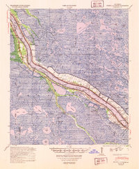
1948 Map of Pointe a La Hache
USGS Topo · Published 1951About this map
The Mississippi River carves a narrow ribbon of habitable land through the marshy expanse of Plaquemines Parish in the late 1940s. This survey reveals a dense concentration of riverfront settlements and agricultural remnants like Beanbury Plantation along the Lower Coast Road. The region's economy is clearly transitioning, marked by the emergence of the Delacroix Island Oil Field and Lake Hermitage Oil Field amidst the labyrinth of coastal lakes and passes. Genealogists will find significant detail in the numerous community landmarks, including the St Jude Sch (Colored) & Cem and the Pte a la Hache Sch. Rail infrastructure is prominent, with the New Orleans and Lower Coast RR and the Louisiana Southern RR following the levees to serve remote outposts like Bohemia and City Price.
Find a feature on this map
87 named features on this map. Tap any name to fly to it.
Don’t see what you’re looking for? This feature index may not catch every label — zoom into the map to look around manually.
Map Details
Editions of this 1948 Pointe a La Hache Map
This is the sole edition of this map. No revisions or reprints were ever made.
Other maps of this area

1891 · Pointe a La Hache
USGS Topo · 1:62,500

1891 · New Orleans
USGS Topo · 1:62,500

1892 · Barataria
USGS Topo · 1:62,500

1892 · Quarantine
USGS Topo · 1:62,500

1892 · Creole
USGS Topo · 1:62,500

1892 · St. Bernard
USGS Topo · 1:62,500

1892 · Pointe a La Hache
USGS Topo · 1:62,500

1893 · Shell Beach
USGS Topo · 1:62,500

1893 · Fort Livingston
USGS Topo · 1:62,500

1893 · Dime
USGS Topo · 1:62,500