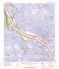
1962 Map of Pointe a La Hache
USGS Topo · Published 1966About this map
The Mississippi River dictates the entire layout of this Plaquemines Parish landscape, with settlements and industry clinging to the narrow levees. Established communities such as Belair, Alliance, and Pointe a la Hache follow the river's bend, supported by the Missouri Pacific railroad. The map documents a deeply interconnected social fabric through its numerous parochial landmarks, including the Blessed Martin Sch & Ch and St Jude Sch & Ch, alongside family-named burial grounds like the Seichsnaydre Cem and Bonneval Cem.
Find a feature on this map
96 named features on this map. Tap any name to fly to it.
Don’t see what you’re looking for? This feature index may not catch every label — zoom into the map to look around manually.
Map Details
Editions of this 1962 Pointe a La Hache Map
This is the sole edition of this map. No revisions or reprints were ever made.
Other maps of this area

1891 · Pointe a La Hache
USGS Topo · 1:62,500

1891 · New Orleans
USGS Topo · 1:62,500

1892 · Barataria
USGS Topo · 1:62,500

1892 · Quarantine
USGS Topo · 1:62,500

1892 · Creole
USGS Topo · 1:62,500

1892 · St. Bernard
USGS Topo · 1:62,500

1892 · Pointe a La Hache
USGS Topo · 1:62,500

1893 · Shell Beach
USGS Topo · 1:62,500

1893 · Fort Livingston
USGS Topo · 1:62,500

1893 · Dime
USGS Topo · 1:62,500