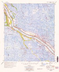
1964 Map of Pointe a La Hache
USGS Topo · Published 1965About this map
The Mississippi River dictates the entire layout of this Plaquemines Parish landscape, with a dense string of historic settlements and plantations clinging to the narrow natural levees. From Belair and the Beaumar Plantation down through Pointe a la Hache, human activity is concentrated between the riverbank and the expansive marshlands of the east bank. This mid-century survey reveals a transition from traditional river-bound life to industrial extraction, shown by the Delacroix Island Oil and Gas Field and the Lake Hermitage Oil and Gas Field emerging from the wetlands.
Find a feature on this map
113 named features on this map. Tap any name to fly to it.
Don’t see what you’re looking for? This feature index may not catch every label — zoom into the map to look around manually.
Map Details
Editions of this 1964 Pointe a La Hache Map
This is the sole edition of this map. No revisions or reprints were ever made.
Other maps of this area

1891 · Pointe a La Hache
USGS Topo · 1:62,500

1891 · New Orleans
USGS Topo · 1:62,500

1892 · Barataria
USGS Topo · 1:62,500

1892 · Quarantine
USGS Topo · 1:62,500

1892 · Creole
USGS Topo · 1:62,500

1892 · St. Bernard
USGS Topo · 1:62,500

1892 · Pointe a La Hache
USGS Topo · 1:62,500

1893 · Shell Beach
USGS Topo · 1:62,500

1893 · Fort Livingston
USGS Topo · 1:62,500

1893 · Dime
USGS Topo · 1:62,500