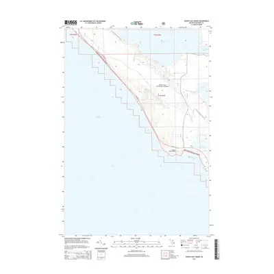
2014 Map of Pointe aux Chenes
USGS Topo · Published 2014About this map
The northern shores of Lake Michigan dominate this 2014 survey, where the terrestrial landscape is defined by the protected acreage of the Hiawatha National Forest. This region of Mackinac County is characterized by its complex hydrology, featuring the expansive Pointe aux Chenes Marshes and the outlet of the Brevoort River into Pointe aux Chenes Bay. The map captures the meeting of land and water at the settlement of Pointe aux Chenes, a point where the coastline turns sharply. Transportation and recreation are central to the area's modern character, with US Hwy 2 W hugging the shoreline while the N Country National Scenic Trail winds through the interior timberlands. Large inland bodies of water, including portions of Brevoort Lake and Round Lake, provide a clear picture of the glacial geography that shaped the Upper Peninsula.
Find a feature on this map
15 named features on this map. Tap any name to fly to it.
Don’t see what you’re looking for? This feature index may not catch every label — zoom into the map to look around manually.
Map Details
Editions of this 2014 Pointe aux Chenes Map
This is the sole edition of this map. No revisions or reprints were ever made.
Other maps of this area

1931 · Epoufette SE
USGS Topo · 1:31,680

1931 · Moran NE
USGS Topo · 1:31,680

1931 · Ozark SE
USGS Topo · 1:31,680

1948 · Moran NE
USGS Topo · 1:31,680

1948 · Moran NW
USGS Topo · 1:31,680

1954 · Sault Sainte Marie
USGS Topo · 1:250,000

1955 · Cheboygan
USGS Topo · 1:250,000

1956 · Sault Sainte Marie
USGS Topo · 1:250,000

1957 · Sault Sainte Marie
USGS Topo · 1:250,000

1958 · Cheboygan
USGS Topo · 1:250,000