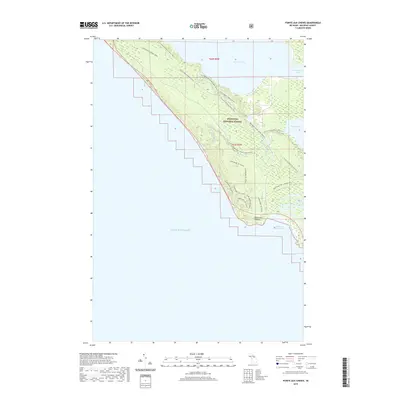
2019 Map of Pointe aux Chenes
USGS Topo · Published 2019About this map
The Hiawatha National Forest dominates this coastal landscape along the northern shores of Lake Michigan. This 2019 survey captures a complex network of recreational corridors that define modern land use in Mackinac County, weaving together the terrestrial N Country National Scenic Trail and the seasonal Sand Dunes Ski (Snow) paths with the riparian flow of the Brevoort River Canoe (Water) route. The geography is anchored by Brevoort Lake and Pointe aux Chenes, where the shoreline transitions into Pointe aux Chenes Bay. This map reveals how the landscape is segmented into townships t42n r5w and t41n r5w, reflecting a strictly managed wilderness where the Brevort River serves as a primary artery between inland waters like Round Lake and the great lake beyond.
Find a feature on this map
15 named features on this map. Tap any name to fly to it.
Don’t see what you’re looking for? This feature index may not catch every label — zoom into the map to look around manually.
Map Details
Editions of this 2019 Pointe aux Chenes Map
This is the sole edition of this map. No revisions or reprints were ever made.
Other maps of this area

1931 · Epoufette SE
USGS Topo · 1:31,680

1931 · Moran NE
USGS Topo · 1:31,680

1931 · Ozark SE
USGS Topo · 1:31,680

1948 · Moran NE
USGS Topo · 1:31,680

1948 · Moran NW
USGS Topo · 1:31,680

1954 · Sault Sainte Marie
USGS Topo · 1:250,000

1955 · Cheboygan
USGS Topo · 1:250,000

1956 · Sault Sainte Marie
USGS Topo · 1:250,000

1957 · Sault Sainte Marie
USGS Topo · 1:250,000

1958 · Cheboygan
USGS Topo · 1:250,000