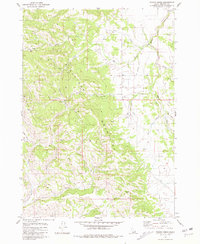
1981 Map of Poison Creek
USGS Topo · Published 1981About this map
The Blackfoot Mountains dominate this high-altitude landscape of Bingham County, where complex drainage systems define the rugged Idaho terrain. The map captures a transition point for several key waterways, including the winding course of Willow Creek and the headwaters of Poison Creek. While the area is largely characterized by uninhabited topography, evidence of human activity and early surveying is marked by features such as the Borrow Pit and a lone Grave located near Mill Creek.
Find a feature on this map
21 named features on this map. Tap any name to fly to it.
Don’t see what you’re looking for? This feature index may not catch every label — zoom into the map to look around manually.
Map Details
Editions of this 1981 Poison Creek Map
This is the sole edition of this map. No revisions or reprints were ever made.
Other maps of this area

1917 · Cranes Flat
USGS Topo · 1:62,500

1918 · Paradise Valley
USGS Topo · 1:62,500

1924 · Hell Creek
USGS Topo · 1:62,500

1924 · Ammon
USGS Topo · 1:62,500

1926 · Hell Creek
USGS Topo · 1:62,500

1955 · Driggs
USGS Topo · 1:250,000

1958 · Driggs
USGS Topo · 1:250,000

1962 · Driggs
USGS Topo · 1:250,000
1963 · Bone
USGS Topo · 1:24,000
1981 · Miner Creek
USGS Topo · 1:24,000