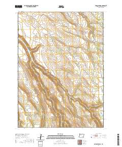
2020 Map of Poison Springs
USGS Topo · Published 2020About this map
The Lambing Ground sits atop a high plateau in this high-desert region of Harney County, illustrating the traditional rangeland usage of the Oregon backcountry. This 2020 topographic survey details an intricate network of seasonal drainages and isolated water sources essential for livestock management, including Wood Camp Reservoir and several named springs such as Poison Springs and Shepherd Spring. The landscape is defined by the deep incisions of Kiger Cr and Cucamonga Cr, which flow southwest toward lower elevations. The map provides a clear look at the Public Land Survey System (PLSS) townships, such as t30s r33e, which organize this sparsely populated territory. Researchers will find a terrain marked by named landmarks like The Lambing Ground, reflecting the region's enduring pastoral heritage and the critical importance of water rights in the arid West.
Find a feature on this map
22 named features on this map. Tap any name to fly to it.
Don’t see what you’re looking for? This feature index may not catch every label — zoom into the map to look around manually.
Map Details
Editions of this 2020 Poison Springs Map
This is the sole edition of this map. No revisions or reprints were ever made.
Other maps of this area

1955 · Burns
USGS Topo · 1:250,000

1955 · Adel
USGS Topo · 1:250,000

1957 · Adel
USGS Topo · 1:250,000

1958 · Burns
USGS Topo · 1:250,000

1958 · Adel
USGS Topo · 1:250,000

1959 · Burns
USGS Topo · 1:250,000

1962 · Adel
USGS Topo · 1:250,000

1967 · Happy Valley
USGS Topo · 1:24,000

1967 · Diamond
USGS Topo · 1:24,000

1968 · Poison Springs
USGS Topo · 1:24,000