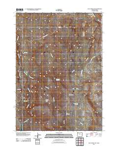
2011 Map of Pole Creek Top
USGS Topo · Published 2011About this map
Spanish Charlie Basin and Strode Basin define the high-desert character of this corner of Malheur County, where the landscape is marked by ephemeral water systems and volcanic outcrops. The drainage of Succor Creek serves as a primary geographical anchor, flowing past Negro Rock and near the historic Rocky Ford crossing. This remote terrain is heavily dependent on managed water resources for livestock and land use, evidenced by the distribution of several basins and reservoirs like Hot Rock Reservoir and Cunningham Reservoir.
Find a feature on this map
18 named features on this map. Tap any name to fly to it.
Don’t see what you’re looking for? This feature index may not catch every label — zoom into the map to look around manually.
Map Details
Editions of this 2011 Pole Creek Top Map
This is the sole edition of this map. No revisions or reprints were ever made.
Other maps of this area

1892 · Silver City
USGS Topo · 1:125,000

1894 · Silver City
USGS Topo · 1:125,000

1898 · Nampa
USGS Topo · 1:125,000

1898 · Silver City
USGS Topo · 1:125,000

1906 · Mitchell Butte
USGS Topo · 1:125,000

1955 · Boise
USGS Topo · 1:250,000

1957 · Sands Basin
USGS Topo · 1:62,500

1958 · Boise
USGS Topo · 1:250,000

1958 · Homedale
USGS Topo · 1:24,000

1962 · Boise
USGS Topo · 1:250,000