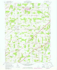
1961 Map of Polk
USGS Topo · Published 1978About this map
The village of Polk serves as the central hub of this northern Ohio landscape, where the Erie-Lackawanna railroad cuts a diagonal path through the countryside. This survey captures a rural environment defined by its historical land divisions, including the North Boundary Connecticut Lands and the Old Seven Ranges, which meeting near the Medina Co line. Local religious and community life is anchored by several country churches, such as St Johns Ch near Albion and Mt Pleasant Ch further south. Genealogists can trace family heritage through numerous burial grounds like Hopewell Cem, Chilcote Cem, and Swope Cem. Along the eastern edge, the industrial landscape includes Sand and Gravel Pits and various Gas Wells, while the Muddy Fork and Redhaw Creek drain the surrounding fields and woodlots.
Find a feature on this map
39 named features on this map. Tap any name to fly to it.
Don’t see what you’re looking for? This feature index may not catch every label — zoom into the map to look around manually.
Map Details
Editions of this 1961 Polk Map
Other maps of this area

1904 · Wellington
USGS Topo · 1:62,500

1906 · Wellington
USGS Topo · 1:62,500

1906 · West Salem
USGS Topo · 1:62,500

1908 · Ashland
USGS Topo · 1:62,500

1908 · West Salem
USGS Topo · 1:62,500

1908 · New London
USGS Topo · 1:62,500

1950 · Marion
USGS Topo · 1:250,000

1956 · Toledo
USGS Topo · 1:250,000

1960 · Nova
USGS Topo · 1:24,000

1961 · Toledo
USGS Topo · 1:250,000