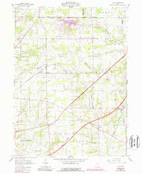
1961 Map of Polk
USGS Topo · Published 1988About this map
Polk and the surrounding townships of Orange and Jackson define this central Ashland County landscape in the early 1960s. The map captures a transition in rural surveying, showing the intersection of the Old Western Reserve and the South Boundary Congress Lands. This historic boundary alignment is flanked by a dense network of country burial grounds, including Hopewell Cem and the Old State Cem, which provide significant data points for local genealogy.
Find a feature on this map
40 named features on this map. Tap any name to fly to it.
Don’t see what you’re looking for? This feature index may not catch every label — zoom into the map to look around manually.
Map Details
Editions of this 1961 Polk Map
Other maps of this area

1904 · Wellington
USGS Topo · 1:62,500

1906 · Wellington
USGS Topo · 1:62,500

1906 · West Salem
USGS Topo · 1:62,500

1908 · Ashland
USGS Topo · 1:62,500

1908 · West Salem
USGS Topo · 1:62,500

1908 · New London
USGS Topo · 1:62,500

1950 · Marion
USGS Topo · 1:250,000

1956 · Toledo
USGS Topo · 1:250,000

1960 · Nova
USGS Topo · 1:24,000

1961 · Toledo
USGS Topo · 1:250,000