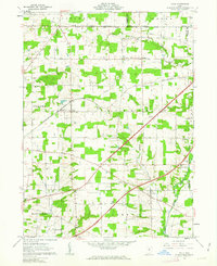
1961 Map of Polk
USGS Topo · Published 1963About this map
Agricultural lands and rural townships in Ashland County define this early 1960s survey, capturing the intersection of historical boundaries and mid-century infrastructure. The landscape is structured by the North Boundary Connecticut Western Reserve Old Seven Ranges, a significant cadastral line separating northern and southern survey systems. The village of Polk serves as a central hub, situated along the Erie-Lackawanna railroad, while smaller settlements like Redhaw and the locality of Goldie appear further south. Numerous family and community landmarks are documented, including Albion Cem, St Johns Ch, and Mt Pleasant Ch. Resource extraction is evident near the eastern edge with several Sand and Gravel Pits noted, while the drainage of the Muddy Fork and Redhaw Creek winds through the predominantly open terrain.
Find a feature on this map
44 named features on this map. Tap any name to fly to it.
Don’t see what you’re looking for? This feature index may not catch every label — zoom into the map to look around manually.
Map Details
Editions of this 1961 Polk Map
Other maps of this area

1904 · Wellington
USGS Topo · 1:62,500

1906 · Wellington
USGS Topo · 1:62,500

1906 · West Salem
USGS Topo · 1:62,500

1908 · Ashland
USGS Topo · 1:62,500

1908 · West Salem
USGS Topo · 1:62,500

1908 · New London
USGS Topo · 1:62,500

1950 · Marion
USGS Topo · 1:250,000

1956 · Toledo
USGS Topo · 1:250,000

1960 · Nova
USGS Topo · 1:24,000

1961 · Toledo
USGS Topo · 1:250,000