1980 Map of Polson
USGS Topo · Published 1982About this map
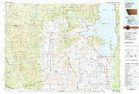
Flathead Indian Reservation lands dominate the eastern half of this 1980 survey, where the massive expanse of Flathead Lake meets the Salish Mountains. The settlement of Polson sits at the southern tip of Polson Bay, serving as a hub for the surrounding ranching and agricultural lands of the Irvine Flats and Valley View Hills. To the west, the landscape shifts toward the high timber of the Lolo National Forest and Kootenai National Forest, with the Thompson River corridor carving through the terrain. The map records a legacy of extraction and water management, from the Flathead Mine and Battle Butte Mine in the north to the Dry Fork Reservoir and Hubbart Reservoir systems that support the arid valleys. The Burlington Northern railroad line provides a critical transportation link through Pablo and Ronan, connecting these southern communities to the larger regional network.
Find a feature on this map
102 named features on this map. Tap any name to fly to it.
Don’t see what you’re looking for? This feature index may not catch every label — zoom into the map to look around manually.
Map Details
Editions of this 1980 Polson Map
This is the sole edition of this map. No revisions or reprints were ever made.
Other maps of this area

1914 · Nyack
USGS Topo · 1:125,000

1918 · St Regis
USGS Topo · 1:125,000

1919 · St. Regis
USGS Topo · 1:125,000

1920 · Flathead Lake
USGS Topo · 1:125,000

1920 · Jennings
USGS Topo · 1:125,000

1921 · Elbow Lake
USGS Topo · 1:125,000

1935 · Thompson Lakes
USGS Topo · 1:96,000

1937 · Thompson Falls
USGS Topo · 1:125,000

1942 · Thompson Lakes
USGS Topo · 1:125,000

1943 · Kalispell
USGS Topo · 1:125,000