
1920 Map of Jennings
USGS Topo · Published 1920About this map
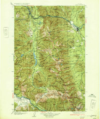
The Kootenai River snakes through this 1920 military survey, serving as a corridor for the Great Northern R.R. and several small timber and rail-side settlements. Located at the intersection of the Kootenai National Forest, Blackfeet National Forest, and Cabinet National Forest, the map reveals a landscape defined by industrial movement and isolated ranching. Named homesteads like Boothman Ranch, Mc Millans Ranch, and the Kenelty Ranch are scattered throughout the river valleys. A notable feature is the Abandoned Roadbed south of Fisher Creek Station, indicating early shifts in rail logistics. From the tiny outpost at Mamicke P.O. to the high-elevation lookout at Wolf Mt. 6500 F.S. Station, the map documents a transitional era when post offices and forest service stations were the primary anchors for remote residents in Lincoln County.
Find a feature on this map
84 named features on this map. Tap any name to fly to it.
Don’t see what you’re looking for? This feature index may not catch every label — zoom into the map to look around manually.
Map Details
Editions of this 1920 Jennings Map
This is the sole edition of this map. No revisions or reprints were ever made.
Other maps of this area

1913 · Stryker
USGS Topo · 1:125,000

1916 · Stryker
USGS Topo · 1:125,000

1920 · Libby
USGS Topo · 1:125,000

1930 · Libby
USGS Topo · 1:125,000
1932 · Libby
USGS Topo · 1:125,000

1932 · Trout Creek
USGS Topo · 1:125,000

1935 · Thompson Lakes
USGS Topo · 1:96,000

1935 · Trout Creek
USGS Topo · 1:125,000

1936 · Trout Creek
USGS Topo · 1:125,000

1937 · Thompson Falls
USGS Topo · 1:125,000