
1930 Map of Libby
USGS Topo · Published 1960About this map
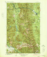
Libby and the surrounding river valleys represent a significant hub of extraction and transportation in the early twentieth century. The map illustrates a landscape defined by the Kootenai River and the Clark Fork, where the Great Northern railroad follows the winding canyon floor past Kootenai Falls. Industrial activity is concentrated at high-altitude claims like the Snowstorm Mine and Snowshoe Mine, while isolated settlements and schools such as Old Town and Bull Lake Sch dot the valleys.
Find a feature on this map
163 named features on this map. Tap any name to fly to it.
Don’t see what you’re looking for? This feature index may not catch every label — zoom into the map to look around manually.
Map Details
Editions of this 1930 Libby Map
This is the sole edition of this map. No revisions or reprints were ever made.
Other maps of this area

1909 · Cataldo
USGS Topo · 1:125,000

1911 · Cataldo
USGS Topo · 1:125,000

1911 · Priest Lake
USGS Topo · 1:250,000

1913 · Priest Lake
USGS Topo · 1:250,000

1920 · Libby
USGS Topo · 1:125,000

1920 · Jennings
USGS Topo · 1:125,000
1932 · Libby
USGS Topo · 1:125,000

1932 · Trout Creek
USGS Topo · 1:125,000

1935 · Thompson Lakes
USGS Topo · 1:96,000

1935 · Trout Creek
USGS Topo · 1:125,000