
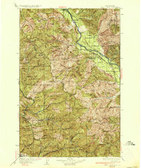
1936 Map of Trout Creek
USGS Topo · Published 1936About this map
Clark Fork defines the northern valley of this 1930s landscape, serving as a corridor for the Northern Pacific railroad and State Highway No 3. Industrial activity is centered around the Tuscor Mill and the Trout Creek Ranger Sta, with small settlements like Noxon and Larchwood supporting the local timber and rail economies. Education in these riverfront communities is managed through local schoolhouses including Tuscor Sch and Birchwood Sch.
Find a feature on this map
138 named features on this map. Tap any name to fly to it.
Don’t see what you’re looking for? This feature index may not catch every label — zoom into the map to look around manually.
Map Details
Editions of this 1936 Trout Creek Map
2 editions found
Other maps of this area

1901 · Coeur D'Alene District
USGS Topo · 1:62,500

1903 · Coeur D'Alene District
USGS Topo · 1:62,500

1906 · Coeur D'Alene District
USGS Topo · 1:62,500

1909 · Cataldo
USGS Topo · 1:125,000

1911 · Cataldo
USGS Topo · 1:125,000

1911 · Priest Lake
USGS Topo · 1:250,000

1913 · Priest Lake
USGS Topo · 1:250,000

1914 · Avery
USGS Topo · 1:125,000

1917 · Avery
USGS Topo · 1:125,000

1918 · St Regis
USGS Topo · 1:125,000