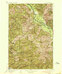
1936 Map of Trout Creek
USGS Topo · Published 1936About this map
Clark Fork carves a deep path through the Bitterroot Range in the early 1930s, serving as the primary corridor for the Northern Pacific railroad and State Highway No 3. This map captures a rugged borderland between Montana and Idaho, where the Kootenai National Forest and Coeur d'Alene National Forest meet. Local infrastructure is concentrated along the river, featuring small settlements like Noxon, Tuscor, and Larchwood.
Find a feature on this map
98 named features on this map. Tap any name to fly to it.
Don’t see what you’re looking for? This feature index may not catch every label — zoom into the map to look around manually.
Map Details
Editions of this 1936 Trout Creek Map
2 editions found

Other maps of this area

1901 · Coeur D'Alene District
USGS Topo · 1:62,500

1903 · Coeur D'Alene District
USGS Topo · 1:62,500

1906 · Coeur D'Alene District
USGS Topo · 1:62,500

1909 · Cataldo
USGS Topo · 1:125,000

1911 · Cataldo
USGS Topo · 1:125,000

1911 · Priest Lake
USGS Topo · 1:250,000

1913 · Priest Lake
USGS Topo · 1:250,000

1914 · Avery
USGS Topo · 1:125,000

1917 · Avery
USGS Topo · 1:125,000

1918 · St Regis
USGS Topo · 1:125,000