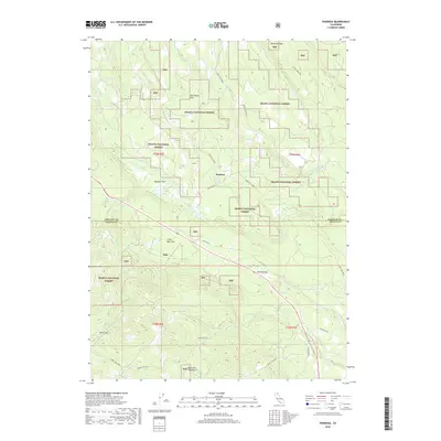
2018 Map of Pondosa
USGS Topo · Published 2018About this map
Pondosa sits as a central settlement within this portion of the Shasta National Forest, straddling the border between Siskiyou and Shasta counties. The landscape is defined by a series of distinct upland flats, including Tom Young Flat, Big Bear Flat, and Kemp Flat, suggesting a terrain of high-altitude plateaus used for seasonal grazing or timber management. A network of Forest Service routes and historical roads like Pondosa Way and Old Co Rd connect the small communities of Obie and Dickson Flat. These routes trace the drainages of Bear Creek and its northern forks, which cut through the forested ridges. The arrangement of meadows such as Bosworth Meadow and springs like Deer Spring indicates a watershed that supported both the local ecosystem and the industrial needs of the surrounding timberlands during this period of the twenty-first century.
Find a feature on this map
33 named features on this map. Tap any name to fly to it.
Don’t see what you’re looking for? This feature index may not catch every label — zoom into the map to look around manually.
Map Details
Editions of this 2018 Pondosa Map
This is the sole edition of this map. No revisions or reprints were ever made.
Other maps of this area

1886 · Modoc Lava Bed
USGS Topo · 1:250,000

1892 · Modoc Lava-Bed
USGS Topo · 1:250,000

1932 · Bartle
USGS Topo · 1:96,000

1939 · Bartle
USGS Topo · 1:125,000

1954 · Alturas
USGS Topo · 1:250,000

1958 · Alturas
USGS Topo · 1:250,000

1961 · Hambone
USGS Topo · 1:62,500

1961 · Pondosa
USGS Topo · 1:62,500
1961 · Big Bend
USGS Topo · 1:62,500

1961 · Bartle
USGS Topo · 1:62,500